


Dubai 2040


Dubai 2040 Urban Master Plan
The Dubai 2040 Urban Master Plan, approved by the Emirate’s government in 2021, is a forward-looking 20-year blueprint for sustainable development. It is the seventh comprehensive city strategy since the 1960s and provides the framework for residential and commercial districts, transport hubs, tourism clusters and protected natural areas.
The plan predicts population growth from 3.5 million today to 5.8 million by mid-century. Its main principle is focusing development around key hubs while protecting 60% of the land for nature reserves and green spaces. This ensures a balance between higher density living, resilient infrastructure and environmental sustainability.
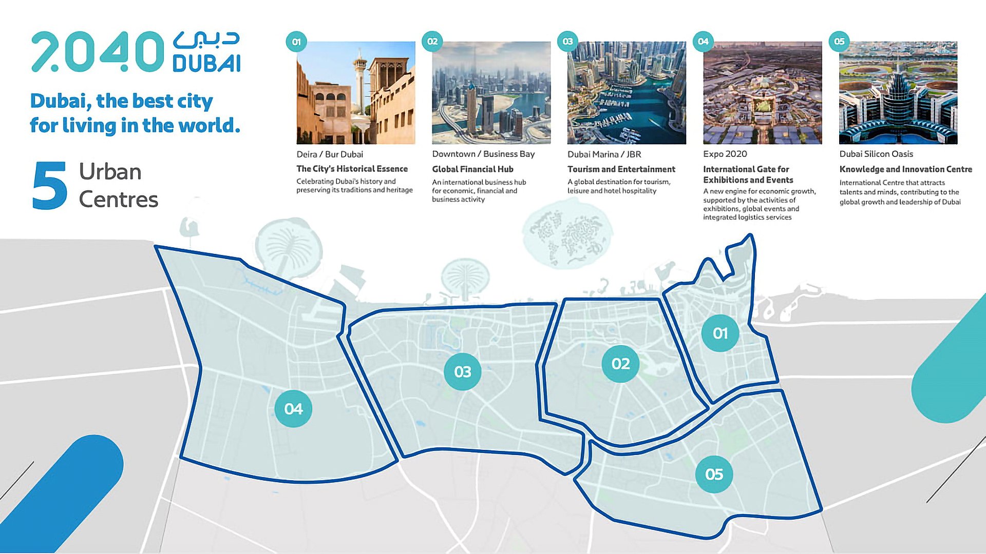
Five Strategic Centres
The city will evolve under a polycentric model, with five distinct centres driving growth:
- Deira & Bur Dubai preserves historic heritage while modernising housing and public spaces.
- Downtown Dubai & Business Bay is the financial and business core, with intensified office development and new transport interchanges here.
- Dubai Marina & Jumeirah Beach Residence is the tourism hub, which expands coastal zones and hospitality offerings.
- Expo 2020 District is transforming into a major exhibition and business cluster, fully integrated with the transport network.
- Dubai Silicon Oasis is a high-tech hub focused on IT and innovation.
This distribution alleviates pressure on central areas and encourages balanced development throughout the emirate.
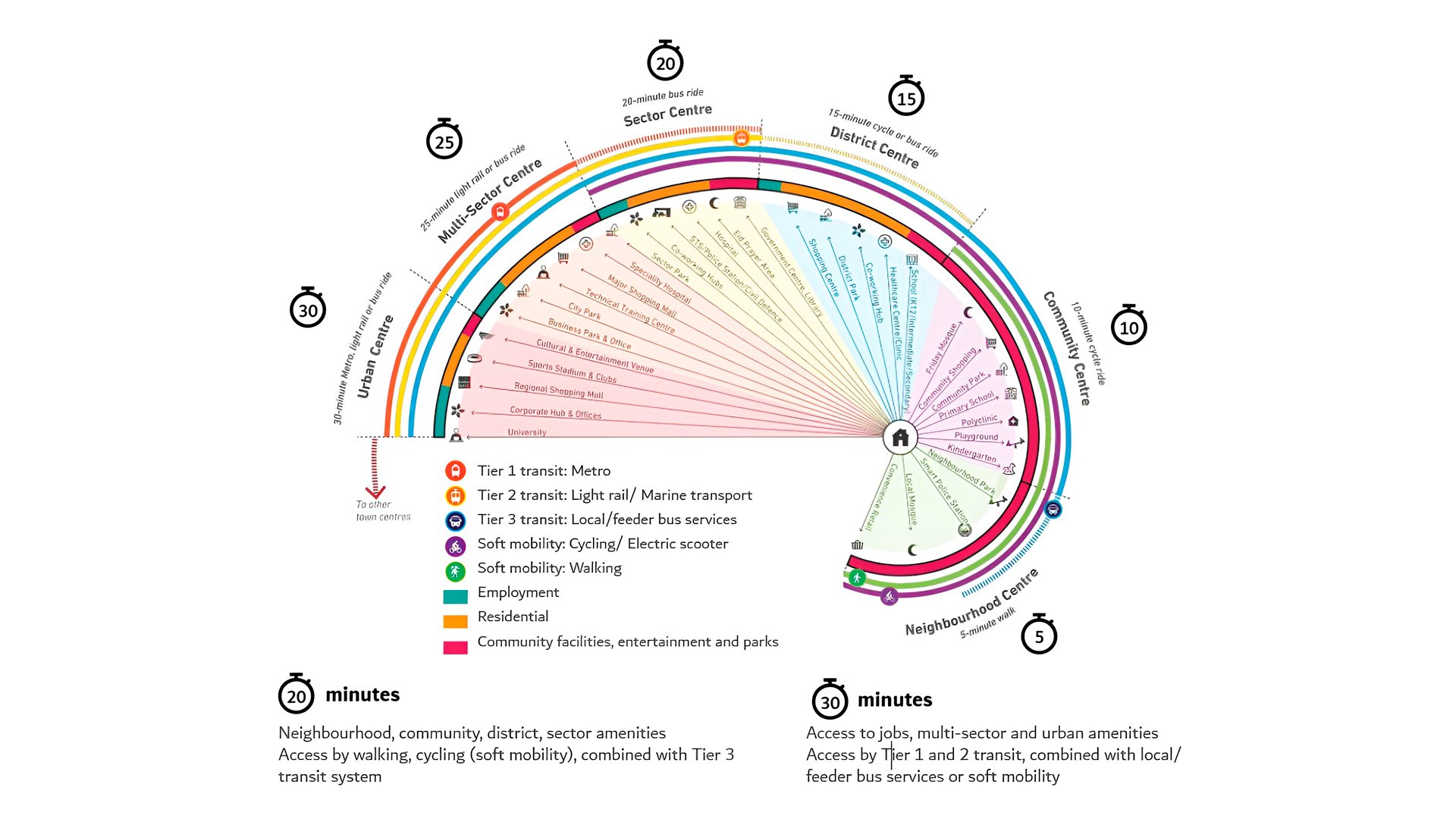
The 20-Minute City
Mobility is at the heart of the strategy, which aims to reduce car dependency while maintaining high accessibility:
- 20-minute city concept: 80% of daily destinations are within a 20-minute walk, cycle or public transit ride. Pilot projects are underway in Al Barsha 2 and Expo City.
- Blue Line Metro: a new 30-kilometre line with 14 stations, connecting Festival City, International City and Dubai Creek Harbour. The launch is planned for September 2029 with a capacity of 200,000 passengers daily.
- Green Spine: Sheikh Mohammed Bin Zayed Road will be transformed into a 64-kilometre eco-corridor with solar trams, shaded bike lanes, heat-resistant surfaces and 1 million new trees.
- Dubai Walk will have more than 6,500 kilometres of pedestrian pathways across 160 districts.
These initiatives support the emirate’s decarbonisation strategy, reducing CO₂ emissions and alleviating congestion.
Tourism and Recreation
Tourism remains a key growth driver. New destinations include:
- Therme Dubai: a 100-metre-tall wellness and leisure resort spanning 45,000 square metres, with Michelin-star dining, waterfalls, indoor and rooftop pools and wellness floors. It’s expected to attract 1.7 million visitors annually.
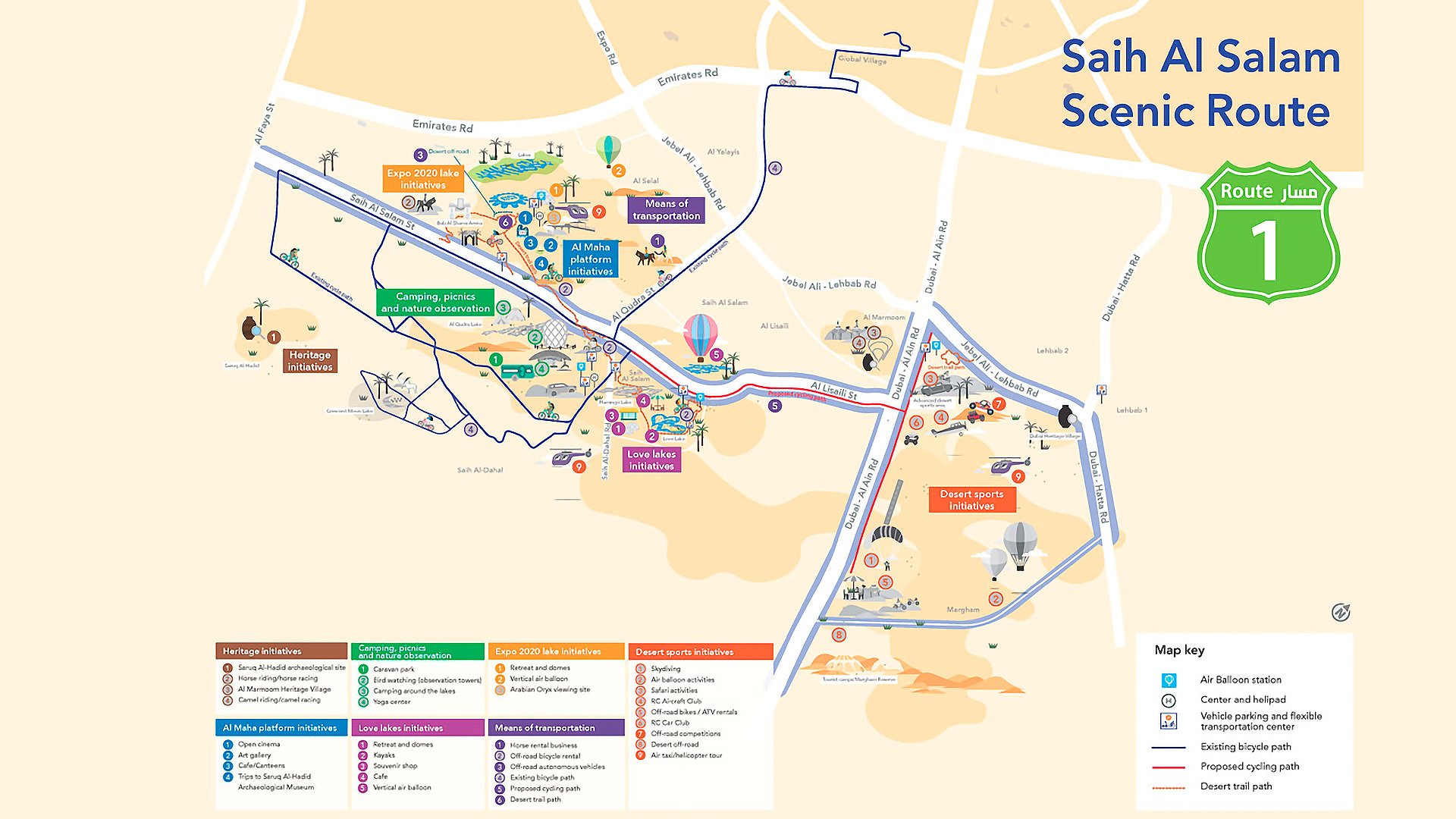
- Saih Al Salam Scenic Route: a 100-kilometre route with five stations offering safaris, camping, open-air cinemas, kayaking and hot air ballooning. The forecast is for 3 million visitors yearly.
- Beach expansion: public beaches to be quadrupled, ensuring greater access to the sea.
- Coastal integration: new promenades, restaurants, bike lanes and viewing decks along the shoreline.
Population growth
The plan contains detailed forecasts for population, employment, and visitor numbers, enabling an assessment of the land resources and space required over the next twenty years.
Dubai's overall population growth is expected to continue to depend largely on the emirate's economic and social initiatives. The emirate's population is projected to increase by nearly 75% over the next two decades, reaching 5.8 million. The number of residents and commuters is also expected to increase by 75% to reach 4.9 million.
Most of the jobs will be created by growth in high-tech and knowledge-intensive sectors, which will increase the demand for land to serve these growing sectors of the economy.
The number of daily visitors to the emirate is expected to grow by 53% as Dubai maintains its status as a global aviation and tourism hub, creating significant demand for additional hospitality services.
| Year | Population (Residents) | Employment (Residents and Non-Resident Workers) | Day visitors (Tourists and Local visitors) |
|---|---|---|---|
| 2019 | 3.3 million people | 2.8 million people | 630,000 people |
| 2030 | 4.6 million people | 3.9 million people | 720,000 people |
| 2040 | 5.8 million people | 4.9 million people | 964,000 people |
Smart City Governance
A new digital management system supports the plan:
- A unified spatial data platform encompassing land use, development, transport and environmental metrics.
- Real-time analytics predicting demand on roads, energy and utilities.
- Open data tools for developers and investors to plan projects more efficiently.
- Smart city technologies with IoT systems, air quality sensors and energy monitoring.
This model allows Dubai to adapt dynamically to global changes and ensure sustainable resource use.
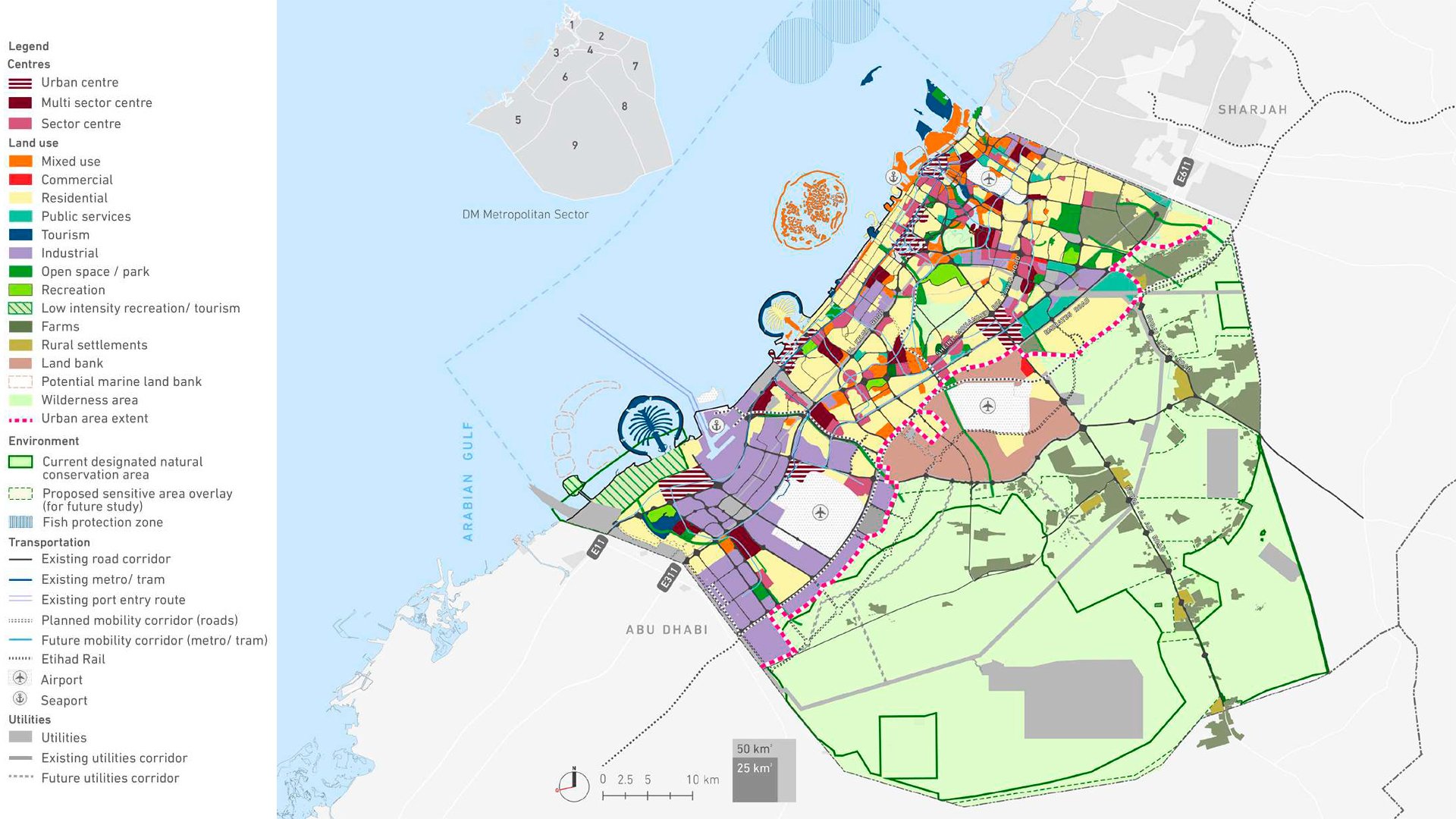
 Рreserving historical relationships
 Protecting the existing conservation areas
 Creating of centres mixed-use areas
 Using unchanged infrastructure and maximising growth areas
 Rational using of marine, coastal and inland waterways
 Enhancing sustainability of rural centers
Inserting green corridors between Dubai’s centres
Staging implementation of projects to ensure the development of growth areas
Enhancing sustainability of rural centers
Inserting green corridors between Dubai’s centres
Staging implementation of projects to ensure the development of growth areas